Overview
Our UK Sales Manager for Scientific Applications, Lewis John, hand-delivered the Mini Micro Pulse LiDAR (MiniMPL) to the British Antarctic Survey (BAS) Cambridge office and provided some introductory training.
The LiDAR then spent time on the RSS David Attenborough studying Southern Ocean clouds before being deployed at Rothera. The unit works reliably on the Antarctic Peninsula today, continuously gathering data on cloud and aerosol layers up to 15km overhead. These detailed vertical profiles allow BAS scientists to investigate cloud formation processes and meteorological phenomena in this pristine environment.
The MiniMPL is a small form factor, low-power, elastic backscatter, polarised LiDAR . Pulses of energy are transmitted into the atmosphere; the energy scattered back to the transceiver is collected and measured as a time-resolved signal, thereby detecting clouds and aerosols in real time.
Client
The British Antarctic Survey (BAS) strives to uncover the secrets of the Polar Regions and the frozen regions of the Earth. Their expertise spans the depths of the oceans to the inner edge of space.
Their research highlights the fragility of the Earth’s frozen environments, and what that means for our planet. They have been living and working in the extremes of Antarctica and the Arctic for over 60 years and their scientists discovered the hole in the ozone layer and identified key evidence for climate change in ancient ice. The BAS’s science continues to inform decision-makers in the present day.
Challenge
The Southern Ocean and Antarctic Peninsula are among the most climate-sensitive and under-observed regions on Earth. Despite their remoteness, they play a major role in regulating the planet’s climate system—absorbing significant amounts of heat and carbon from the atmosphere.
However, our understanding of how clouds form, evolve, and interact with radiation in this region is still limited. These processes strongly influence the Earth’s energy balance and the pace of polar amplification (the phenomenon where polar areas warm faster than the global average).
The MiniMPL helps address this knowledge gap by providing detailed, continuous vertical profiles of clouds and aerosols, enabling scientists to study the microphysical and dynamical processes at play.
Clouds over the Southern Ocean are a major source of uncertainty in climate models. Many models underestimate cloud reflectivity (albedo), causing them to absorb too much solar radiation, which skews temperature and energy balance predictions.
By helping to measure cloud height, thickness, and layering, the MiniMPL helps refine satellite observations and improve how models simulate cloud behaviour in cold, clean environments.
Polar regions are also among the last places on Earth where scientists can observe clouds forming in ultra-clean air—with very low aerosol concentrations. Studying how even small amounts of aerosols (natural or transported from distant sources) impact cloud microphysics is crucial for understanding cloud lifetimes, precipitation processes, and cloud radiative properties.
The MiniMPL helps BAS scientists detect aerosol layers, observe their vertical distribution, and track their influence on nearby cloud systems.
Understanding the structure and evolution of the planetary boundary layer (PBL) in polar climates is essential for forecasting surface weather conditions, including wind, cloud cover, and temperature. The Antarctic PBL behaves very differently from temperate regions, often becoming shallow and stable due to strong surface cooling.
The MiniMPL provides real-time PBL height detection, which can allow researchers to study how this layer interacts with clouds, inversions, and katabatic flows.
In addition, remote sensing from space over snow and ice is notoriously difficult, due to surface brightness, frequent cloud cover, and limited ground truth data. Having a reliable, ground-based LiDAR system like the MiniMPL at Rothera helps validate and calibrate satellite-derived products, improving confidence in polar climate observations.
Solution
The Mini Micro Pulse polarised LiDAR (MiniMPL) is a small form factor, low-power, elastic backscatter LiDAR.
What is LiDAR technology?
LiDAR stands for Light Detection and Ranging (LiDAR)
- Pulses of laser energy are transmitted into the atmosphere; the energy scattered back to the transceiver is collected and measured as a time-resolved signal, thereby detecting clouds and aerosols in real time.
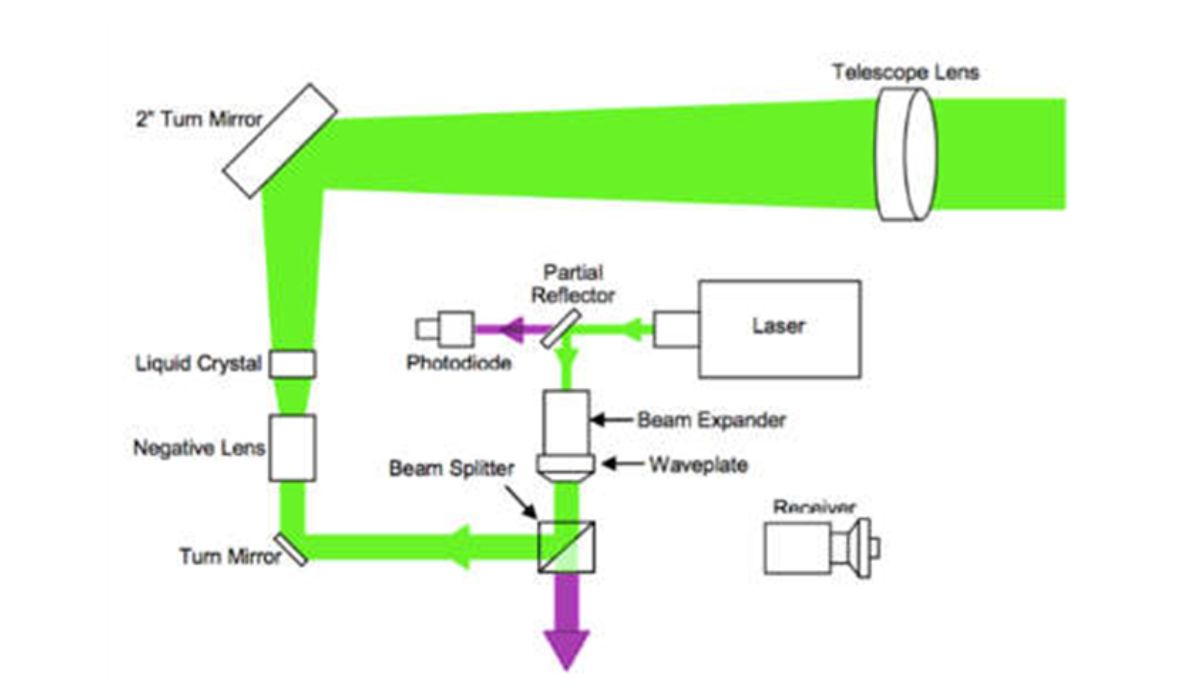
- The transmission path starts at the laser. The beam is first expanded, and then the polarisation orientation is set. Finally, the laser goes through a second stage of expansion before it leaves the telescope. Two polarisation states leave the MiniMPL, co-pol and cross-pol.
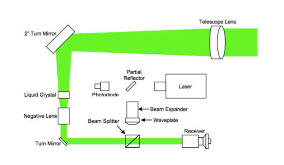
- On the return path, light that has been scattered off particles in the atmosphere enters the MiniMPL and follows the same path as the transmit beam. Once it enters the telescope, it is collected by the receiver and focused onto the detector
In short, pulses of energy are transmitted into the atmosphere; the energy scattered back to the transceiver is collected and measured as a time-resolved signal, thereby detecting clouds and aerosols in real time.
The MPL (Micro Pulse LiDAR) and MiniMPL (Mini Micro Pulse LiDAR) are the only LiDAR systems currently approved for use across three of the world’s most respected atmospheric observation networks: NASA’s Micro Pulse Lidar Network (MPLNET), which provides global ground-based LiDAR measurements for satellite validation and aerosol-cloud research; the U.S. Department of Energy’s Atmospheric Radiation Measurement (ARM) program, a long-term climate research initiative that operates observational facilities around the world to improve the understanding of atmospheric processes; and EUMETNET (the Network of European Meteorological Services), a collaborative framework that supports coordinated observations and forecasting services across Europe.
Further applications
It supports a wide range of atmospheric science and environmental monitoring applications. It plays a vital role in planetary boundary layer characterisation, providing insights into vertical mixing processes and boundary layer height—key parameters for weather prediction and climate studies.
The system is also used in pollution characterisation, helping to identify and track layers of urban smog, industrial emissions, and long-range aerosol transport. In weather modification research, the MiniMPL contributes to understanding cloud seeding effectiveness and cloud microphysics. It is a valuable tool for wildfire monitoring and prediction, detecting smoke plumes and tracking their vertical dispersion.
Additionally, the system aids in plume monitoring from both natural and anthropogenic sources, including volcanic eruptions and power station emissions. In urban environments, it supports air quality monitoring and forecasting, enabling early warning systems and public health assessments by capturing real-time changes in aerosol concentrations and boundary layer dynamics.
Client benefits
- Detailed, continuous vertical profiles of clouds and aerosols
- Delivers advanced cloud and planetary boundary layer data for atmospheric profiling up to 15 km
- Supports fast decisions based on accurate and reliable information
- Aids in plume monitoring from both natural and anthropogenic sources
- Real-time PBL height detection, which can allow researchers to study how this layer interacts with clouds, inversions, and katabatic flows
See the MiniMPL running for several hours at Rothera Research Station, in the Antarctic Peninsula:
Further Reading
See a list of journal articles around clouds and Polar Atmosphere from recent years, featuring the MiniMPL:
- 2021 – Xie, Hailing, Zhien Wang, and Xiaohong Liu. “The comparison of long-term aerosol profiles under clear and cloudy conditions at Arctic using ground-based micro-pulse lidar measurement.” AGU Fall Meeting Abstracts. Vol. 2021. 2021.
- 2021 – Kuji, Makoto, et al. “Characteristics of cloud fraction and shortwave downward radiation at Ny-Ålesund and Syowa station.” The 12th Symposium on Polar Science 15–18 November 2021.
- 2022 – Xie, Hailing, et al. “Seasonal Variation of Dust Aerosol Vertical Distribution in Arctic Based on Polarized Micropulse Lidar Measurement.” Remote Sensing 14.21 (2022): 5581.
- 2024 – Whitehead, Luke Edgar, Adrian James McDonald, and Adrien Guyot. “Supercooled liquid water cloud classification using lidar backscatter peak properties.” Atmospheric Measurement Techniques 17.19 (2024): 5765-5784.
- 2025 – Hines, Keith M., et al. “Skillful Polar WRF Cloud Modeling of a Warm Winter Atmospheric River at the Antarctic Peninsula.” Authorea Preprints (2025).
- 2025 – Lolli, Simone, et al. “Long-term trends in daytime cirrus cloud radiative effects: Analyzing twenty years of Micropulse Lidar Network measurements at Greenbelt, Maryland in eastern North America.” EGUsphere 2025 (2025): 1-23.